"[McBride] added that another key component to improving cycling in Newark is working with the University of Delaware, which he said has fallen behind competitors like Penn State and the University of Maryland as it relates to cycling infrastructure. McBride said UD “hasn’t been all that interested in helping us,” noting that UD’s interest in cycling waned after a student was fatally struck by a bike outside the Trabant University Center in 2015."
It is no secret that Earl "Rusty" Lee of the University of Delaware's Department of Civil and Environmental Engineering Faculty is anti-bicycling. We have heard it from past students and overheard U.D. alumni saying as much. It was objectively obvious during the Shared Right Turn-Only Lane project 12 years ago. DelDOT tasked U.D. with conducting field and human factors testing and providing the data necessary to have this vital modification added to the Delaware MUTCD.
Surely, we cannot prove Mr Lee's complicity in UD's attitude in the Post article above. But their unwillingness to help Newark move toward a green sustainable transportation future is repugnant at best. Apparently, it is based this on a single bike-ped accident at Trabant Student Center that resulted in a fatality.
The University and Mr Lee should be reminded that bike collisions with pedestrians (resulting in death or serious injury) are exceptionally rare compared to cars. People dependent on cars result in 38,000 road deaths per year in the U.S. (this includes in Newark) and costs everyone many billions of dollars in medical services and property damage. There are also the health implications of driving costing 10s of thousands of lives every year. These include respiratory illness, noise anxiety/stress, obesity etc. Instead of holding a grudge, U.D. should be at the forefront getting people out of cars and into active (pdf) modes like bicycling. They should also provide a car-share system instead of minimum parking requirements for students.
The revolution in e-Bike and scooter technology alone all but mandates U.D. to act, as hundreds if not thousands of their students depend on these modes to get to class. Needless to say, oil-dependent transportation accounts for the largest share of heat trapping emissions, ultimately dooming our planet. U.D. should also provide multi-modal education and provide a monthly stipend to the Newark Bike Project. NBP is a huge asset, helping their students fix and maintain their bikes while teaching them self-reliance in this manner.
Shame on the University of Delaware for waving the environmental baton while jamming it in the spokes of people on bikes, those trying to be "one less car".
The typical DelDOT "shared use" curb cut, in clear violation of AASHTO guidance
2012 AASHTO Guide for the Development of Bicycle Facilities (pdf)
5.3.5 Other Intersection Treatments: Curb Ramps and Aprons The opening of a shared use path at the roadway should be at least the same width as the shared use path itself. If a curb ramp is provided, the ramp should be the full width of the path, not including any side flares if utilized. The approach should provide a smooth and accessible transition between the path and the roadway.
AASHTO No-No: Sidewalks as "Bikeways", signed as such
DelDOT's Pavement & Rehabilitation section routinely installs as little as 4' wide ramps and island cut-throughs on bi-directional shared-use pathway (SUP) facilities. According to AASHTO guidance, this practice relegates these facilities to sidewalks. Perhaps nobody even notices this, after all, "why build good bike facilities, when nobody rides because of the lack of good facilities?" ~Barry Childress (Chair, Baltimore Spokes).
According to unnamed experts in the field, DelDOT's ignorance of AASHTO makes them responsible in the advent of an accident or crash. Further, the installation of signs indicating these are bikeways, when in fact bicycle equity and safety is gravely compromised should be an embarrassment to the Department. It also indicates just how involved the various advocacy orgs (DE Bicycle Council, DE Greenways, Bike DE, etc) are in "connecting everyone with a bicycle-friendly transportation network".
All of the $44M in RAISE funds granted to DE are going into two high profile projects that will fix none of the problems with Delaware's current bicycling infrastructure. Most of what we see now is in a state of disconnect and ruin, and will stay that way thanks to the above parties. Instead of developing design guidance for SUP width and alignment through stroad intersections, for example, and turning the countless "goat paths" in New Castle County into AASHTO-compliant pathways, every dollar goes to benefit a tiny minority.
The installation of grossly inadequate "multi-modal" infrastructure continues unabated in Delaware, and will guarantee that we remain a whopping ~0.02% bicycling modeshare. The State will continue as most dangerous in the U.S. for bicyclists and 2nd most deadly behind Florida. Oil-based transportation is the #1 source of AGW emissions, as our "leaders" in govt agencies and non-profits (most of whom never actually bike, or even walk apparently) make the decisions that seal this fate. Shame on all of them.
10' wide is reduced to 5' on the Linden Hill shared use pathway at Skyline Drive in Pike Creek
The massive growth of "convenience" superstores, and their vast array of mega-gas pumps and car-infested parking lots is fast destroying any notion of a bikeable greater Newark. In the past, residents from within City limits have been able to defeat the plans of these greedy corporations and their billionaire CEOs and investors -- particularly along Elkton Rd/new S. Main Street. Such spotty success, however, sends the message that bicycling for transportation is unique to select small areas, like college towns. Yet the vast majority of car trips made in the U.S. are generated in suburbs and are less than a mile long. This is a distance easily biked or walked by at least 2/3 of Americans, but our so-called leaders in local and State govt and their supporting organizations aren't interested in that.
Key Excerpts: Commissioner Christopher Williamson expressed dismay that Wawa is seeking to come to an area already crowded with gas stations. Wawa would be the fifth gas station in the 1-mile stretch of South College Avenue leading up to the I-95 interchange. A sixth gas station, a Dash In, is proposed for across the street at the site of the Rodeway Inn.
“Talk about a bleak landscape between West Chestnut Hill Road and the freeway. It’s disappointing it’s turned out this way. I know it meets code, I know that it’s economics that drives what you can put there,” Williamson said. “That one little shopping center and Jersey Mike’s, there’s hardly a blade of green grass in there. It’s pretty bleak looking. I just wish the city could have gotten ahead of it, but it’s too late, the train is out of the station.”
Despite expressing concerns about the project, the planning commission voted 6-0 to recommend city council approve a minor subdivision and special-use permit for the Wawa. A date for council consideration has not yet been scheduled.
The Wawa proposal voted on Tuesday is one [FOUR MORE] being proposed in and around Newark [Full article . . .]
Newark is even on board for annexing the necessary land to encourage WaWa's gross expansion. As such, the promotion and approval of these cancerous blights will be the City leader's 'legacy'. Instead of planting trees, in their minds, it is more important to destroy the environment, lock in car-dependency, and ruin any sense of placemaking. They, and their New Castle County cohorts in "Planning" and Land Use are the antithesis of One Less Car and are equally to blame for this disaster. Shame on everyone involved.
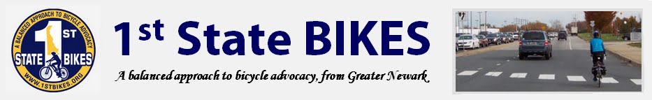
From the event site | Please join us in a Celebration Of Life for Angela Connolly Cunneely, who took her leave of this earthly realm on August 4th 2023. Obituary HERE.
Angela fought a valiant 2 year battle with Cholangiocarcinoma, a very rare and aggressive cancer of the bile duct, which ended in the way that Angela always knew it would - in a draw. She always knew that her cancer would ultimately take her, but she took solace in the fact that her end would also mean the demise of her cancer.
In keeping with the spirit of Angela’s love of and connection to nature and the great outdoors, we will be gathering on Oct 8 at 2pm in Lums Pond State Park, Pavilion #3. Please dress comfortably and respectfully.
One of Angela’s favorite movie lines and frequently used quotes was “I don’t mind going if a luncheon is provided” from A Christmas Carol ❤️, and as such food and drink will of course be provided by the family, and any additional contributions are most welcome.
This video is a collaboration of Frank Warnock of 1st State Bikes and Mario Nappa. With Mario hosting, Frank Warnock answers questions about the hazards of riding on a 1/2-mile stretch of Salem Church Road between the I95 overpass on the north end to Old Baltimore Pike on the southern end.
At the end of the video we give you contact information so you can connect with your state representative to encourage that bike lanes are added along this section for the safety of cyclists, pedestrians, and motorists.
Thank you for watching and for your help in making Bike Route One a safer place to ride.
Angela Connolly Cunneely, 64, passed away at home on August 4 after a courageous battle with cholangiocarcinoma, a rare and virulent cancer of the bile duct. Angie was born on June 22, 1959 in the Bronx, New York City, to the late Margaret (Jantek) and Edward Connolly. She married her high school sweetheart Martin when he joined the Navy, and together they lived in Tennessee, California, and Washington state before settling back in the Bronx. There, Angie was active in the PTA when her children were in school, then studied ESL at Lehman College where she helped many adult students learn English.
After the family moved to Delaware in 1989, Angie earned her Certification as a Medical Assistant and worked for many years in women's health, where she was known for her competent and compassionate care for her many patients. She became active in her new community as well, volunteering with both Bike Delaware and the Newark Bike Project. She also fought tirelessly for the preservation of the former Orphanage property on Chestnut Hill Road.
In addition to her advocacy, Angie's interests included caring for her lush garden, flying in small planes, and traveling to the Dominican Republic and throughout Europe.
Angie was predeceased by her parents and brother Edward. She is survived by her husband Martin, her son Martin Jr. (Shelley), daughter Melissa Schweitzer (Rob), grandchildren Connor, Tyler, Lilah, Jake, Eva, and Ella, and her two sisters Mary-Catherine Connolly and Marguerite Cain (Dave), as well as many nieces and nephews and her little dog Midnight. | (see it on legacy.com)
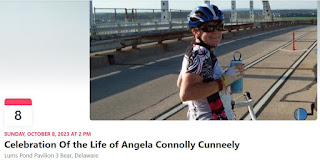
Editor's note: Angela was a superb advocate and activist for walking, bicycling and environmental causes in Delaware. She volunteered and served on the boards of multiple organizations that included Newark Bike Project and Bike Delaware in their early inception. Angela co-founded Save The Orphanage Property (STOP), a coalition of citizens and organizations that attempted to save green space and bring a regional park to Ogletown-S. Newark. She co-wrote and edited for several advocacy blogs that included 1st State Bikes and Ogletown Resilience. Her beautiful personality, lively enthusiasm, and embrace of the greater good will be sorely missed.
WILMAPCO is appealing for feedback to reverse the "1st" that Delaware asked for over many decades time with poor land-use and infrastructure planning. Kudos to them for making this big step. But if our State is really serious about reducing injuries and fatals, it is going to take more than infra improvements on gov-owned roads and other public rights of way (ROW). In no particular order, here is our top 12 recommendations that SSFA (Safe Streets for All) must consider and implement to be effective:
Reform the vehicle code for pedestrians. DE's code now ranks among the most inadequate and dangerous in the country. Bike Delawarefought and defeated past attempts at bringing said code in line (pdf) with other truly progressive States.
Typical goat path from SR4 in S. Newark
A holistic approach to infra that includes non-state lands and properties, e.g. abaondoned roads, "goat paths" and/or other potential buy or easement possibilities. These make critical connections e.g. Cavaliers to Christiana Mall, yet are actually discouraged! Shared-use pathways are paved parallel to shopping centers or strip commerce, but the only "connections" are goat paths traversing high curbs or over high fences. Ditto with neighborhoods and other vital destinations. This is grossly unacceptable and any safety campaign must address this issue. That said, the NCC "Safe Streets for All" interactive mapping tool is a great start; please participate.
"20 is Plenty" (or similar) for neighborhoods and side streets, including replacement of all 25 mph speed limit signs (Sen John Walsh performed a cost analysis), accompanied by an awareness campaign. This has had demonstrable results elsewhere in western society (i.e. Europe).
Restrict use of radial turns and slip lanes to high speed roads only; these should never be used on streets at human scale, which DelDOT continues to do. Roads should have limited access via frontal streets only; Streets require crossroads to be safe. There is a big difference.
Lower speed limits on arterial roads that have frequent red lights, crosswalks, bike lanes, shopping centers, schools etc. SR4 (E. Chestnut Hill Rd) thru Ogletown-S.Newark is posted at 50 mph, which is recklessly dangerous. Average speeds approach 60 mph, even through intersections where the East Coast Greenway parallels a deaf-blind and elementary school according to one speed study. Eliminate the 85th Percentile as exclusive guidance when setting speed limits.
Carth Vader
Robust laws aimed at curbing drag racing and aftermarket and modified exhaust systems. Such vehicle terrorism discourages anyone from venturing near DE's arterial roads and streets unless forced. And we all have connections that can only be made via arterial roads. Sen Walsh/Rep Williams already passed HB328 for the former, and HB35 is in process for the latter. PD and/or NCC follow-up to citizen complaints is key to enforcement. Kudos to the legislators involved.
Redundant DMV driver training. Even a simple periodic quiz would help, perhaps with renewals. License and registration as a "right" has to end, replaced with the privilege to drive AND re-earning it from time to time.
A gas tax to fund improvements across all vulnerable user types, given the unspeakable damage caused by people driving cars and burning fossil fuels vs non-motorists.
Bike parking with ALL new commercial establishments (NCC), including refurbs -- not just ground-up construction. Find a way to incentivize existing services and establishments. Reform the land-use code in this manner.
Stop using cement barriers and hanging cables instead of bollard(s) where bike/ped but not cars are permitted. This is lacking of common sense and results in tripping or crash hazards.
Design, test and implement a Delaware MUTCD-specific Shared Zone signage, for use in mixed zones where speeding is notable. Examples include Creek Road north of Newark.
Car-free and car-lite housing incentives at Delaware's schools, colleges and universities. This includes reducing student car parking and replacing it with car-sharing services instead.
Is there a #13 and beyond? Where is Bike Delaware and Delaware Greenways on any of these issues? Let us know in the comments section below if you have anything to add. Beyond that, this post marks the end of what we can do to help Delaware move forward in multi-modal safety and quality of life issues. Now on to populating the SSFA map.
Sadly,DelDOT has denied Advocate's pleas for Shared Zone signage on Creek Road. Creek Road is a historic, narrow, 2-lane, unimproved rural route that extends from Newark through the White Clay Creek Valley. It is especially rich with pedestrian and bicycling activity just north of Newark, given University of Delaware's vast student population. It was abandoned for auto use starting about 0.8 miles south of Wedgewood Road, as much of the asphalt collapsed into the White Clay Creek, but enough width remains for dedicated trail use.
Creek Road is not actually a road; though rural, it qualifies as a Street and shared-use path (Pomeroy Trail) system. Upon our initial ask, Delaware State Parks eagerly embraced the idea and installed Shared Zone signs on DSP-managed roads open to automobiles. However, despite Creek Road having the highest mode-share by far, DelDOT wouldn't allow it. In a response from a DelDOT spokesperson:
DelDOT has implemented the low stress bikeway practices and designs. The Newark Bikeways signs was collaboration between Bike Newark, Wilmapco, Delaware Greenways, City of Newark and DelDOT. Traffic’s view is that this portion of Creek Rd is dedicated to highlight the low stress Newark Bikeway as far as signage is concerned. We don’t recommend any additional signage at this
time. We can engage the City of Newark to see if they would like to
include any in their limits along Creek Rd.
Traffic Studies also worked with Captain McDerby and Park Superintendent Lee with the posting of additional 25 mph speed limit signs. They stated it is a huge help with providing pedestrian, bike safety on this road for visitors entering White Clay Creek State Park.
Sure, speed limit signs where before there were none helps. But DelDOT is citing the small, brown, relatively inconspicuous "Low Stress Bikeway" sign as adequate. We disagree, especially since bikes are the minority of non-motorized users, and cars -- many speeding -- are expected to mix with majority walkers, hikers, runners etc.
If DelDOT is so mired in regulations that they cannot make this simple improvement, then they must develop, test and approve a similar custom sign for Delaware's MUTCD (traffic devices manual pdf). Advocates have offered to help, similar to the W11-1-DE project, but DelDOT has declined to answer.
When common sense is defied in such a manner, we cannot help but question the State's sincerity in terms of non-motorized encouragement and safety, climate mitigation and the greater good. Let's hope things change, and that DelDOT engineers and planners are given more autonomy to create safe streets environments.
Shared Zone implemented throughout White Clay Creek State Park -- except on Creek Road where it's needed most.
With the approval of a Historical Marker commemorating Ogletown, and a quarter millennia since the passing of its founder, the time has come to improve multi-modal access to this historic site. Regional legislators, including Senator Jack Walsh, have already agreed on action to address the failed infrastructure surrounding Thomas Ogle's tomb and green space. This includes the East Coast Greenway (ECG) west from SR273, and two connectors: one to Prides Crossing and the other to Chestnut Hill Estates via Old Ogletown Rd.
More recently, we discovered the gross lack of zebra striping of the ECG (streetview) through Chestnut Hill Plaza, a Meineke repair shop, and a Liberty gas station. Meinekie has even adopted the ROW as defacto car parking. This facility was originally paved at the width (8') required for bidirectional bike-ped traffic, and is eroded and narrowing in many sections. It rises up and back down through driveways, when the opposite is required for traffic calming and multi-modal awareness. Adding zebra crossings won't fix the problem of high speed entrances from SR4, but will bring awareness (and thus some added safety) for ECG users and Ogletown destination-making.
ECG just west of Augusta Drive
We were rebuffed in an effort to improve the Augusta Drive intersection further west. Instead, ECG continuity was broken, with a new, cars-only signal upgrade. Further west, driveways at the DE School for the Deaf (DSD) are properly aligned and zebra striped, as seen in the photo right. It would appear that Complete Streets is being applied sporadically, or by socio-economic status, with consequences that could take decades to fix.
The long range goal for the ECG is a continuous facility brought up to modern design standards, some of which can be found further to the east. Recent setbacks like Augusta, however, only cement Ogletown among the disenfranchised. When asked, there are few to no answers from several oversight orgs. In contrast, Advocates should be pouncing on each and every opportunity to improve the ECG -- even with basic highway maintenance projects as called for in DelDOT's Complete Streets policy.
This proposal to enhance placemaking in Ogletown would bring some consolation -- not just for Thomas Ogle but also the loss of the Orphanage Property as a regional park -- the chance of which will never come again.
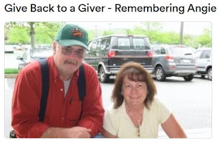
First 2 months of 2022. Multi-year sampling periods confirm the
trend we are on. Click on image above for the latest numbers.
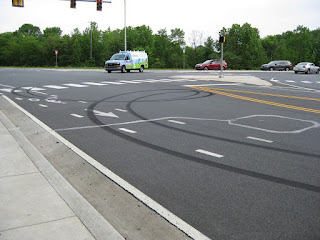
Statistically, Delaware is heading for a road safety disaster in 2022 - in particular New Castle County. Speeding, aggressive and distracted driving is rampant, with per-capita injuries and fatalities on pace to surpass even Florida. Despite strict laws to the contrary, many (if not most) offenders have a State-approved aftermarket and/or modified exhaust system. These behaviors account for why virtually nobody rides a bicycle for transportation or recreation -- even after 10 years of Complete Streets policy implementations.
There is virtually no pro-active law enforcement, particularly within Delaware's vast unincorporated zones. Police are few and far between, and spend most of their time answering 911 calls. An active and growing minority of drivers know this, as evidenced by the many vehicles now sporting fully tinted windows (also illegal). Even the City of Newark won't enforce the most deafening and disturbing of "loud mufflers". The lack of such basic government services has Delaware ranking criminally awful (CFPI), especially in matters of transparency. It is a top-5 worst State to live on several key socio-economic fronts, and consistently ranks as most dangerous to walk or ride a bicycle .
Our safety and quality of life is being destroyed right in front of our eyes; vehicle assault and violence is deafening our ears and ruining our health. County and State legislators offer token support, sometimes introducing bills that build on existing laws -- but these come up woefully short on enforcement. Organizations that claim to advocate for bicycling and connectivity have either given up on road safety or appear to be co-opted.
Minus a paradigm shift, and a mass conscience re-awakening toward the common good, things are only going to get worse. The suburbs, which comprises the vast majority of Delaware's built environment, are "entropy made visible", and will not be rescued unless we collectively change our thinking.
The above assaults are becoming more and more prevalent, even on Delaware's "quieter" neighborhood streets. We are trying to obtain 911 call data, that shows that this is among the most frequent emergency call types in New Castle County (stay tuned).
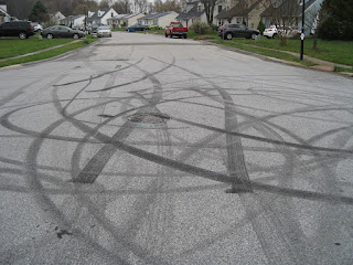
Above: "Bike Lane" on Red Mill Road in Ogletown. Authorities often question as to why so few people ride in Delaware, yet the answer is laid in rubber for all to see.
The W11-1-DE signs were removed from Paper Mill Rd at the White Clay Creek road bridge in Newark, upon the installation of a new pedestrian bridge. This sent the wrong message to car drivers that bicyclists are required to use this new bridge to circumvent the road bridge. We requested that the W11-1-DE signs be re-installed since bicyclists are legally permitted and will continue to use the road and its bike lanes. Failure to do so will result in drivers harassing bicyclists, given the new bridge is in plain sight.
While this new bridge is a valuable amenity, the apparent switch to mandatory-use for bicyclists is problematic for 2 reasons:
It requires two crossings of 2 lanes of high VMT traffic in the northbound direction of Paper Mill Rd, which is statistically more dangerous, and more time consuming, and
Much of the pathway between the new bridge and Curtis Mill Park is 5' wide and not the min. 8' required to be safe. Therefore, it does not qualify as a bi-directional facility (this alone makes it ped-only) according to DelDOT's manual (pdf).
In this current config, the new bridge and its connecting pathways and crosswalks are not a suitable replacement for experienced bicyclists. DelDOT immediately responded, and re-installed the W11-1-DE signs on Mon Jan 24, and for that we are grateful.
Given how many people (esp students) ride the sidewalk now, it would certainly help if there was the required 8' asphalt SUP connected from the Old Paper Mill Rd crosswalk to the Pomeroy Trail. Regardless, we should never remove bicycling safety infra (in this case signage and sharrows) from the road. You can still see the signs in Streetview HERE.
Original W11-1-DE sign at Paper Mill Rd bridge southbound
With us backing him, Mark Luszcz (DelDOT Chief Traffic P.E. at the time) did a lot of work to get these signs approved and out there. This resulted in the removal of hundreds of "Share the Road" signs, replacing a mere fraction with W11-1-DE in strategic locations. This includes pinch points like the Paper Mill Rd road bridge. It was a big contribution in the reduction of sign clutter. It was also -- tho' not officially -- a compromise with P.E.s who don't like "Bicycles May Use Full Lane", because that sign (R4-11) preceded this one at this bridge and it was switched out unannounced.
Even if there is a project someday to connect 8' of asphalt between the Curtis Mill Park and the Pomeroy Trail, there are still bike lanes on Paper Mill Rd, so the signs should remain -- now more than ever actually. Kudos to DelDOT for listening, and answering the call of safety.
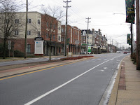
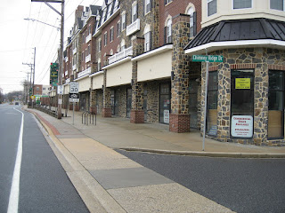
Why has Newark's "New" South Main Street failed to capture the cultural and historic richness that every U.S. Main Street should enjoy? Why hasn't it lived up to the civic and place-making ambiance (albeit eroded) of the City's East Main Street?
Writer and journalist James Howard Kunstler demonstrates the failure of modern U.S. architecture and civic design in this 19 minute TED Talk. The failure of South Main Street begins at 9:22, or HERE, and could not be more apparent.
Unfortunately, such reckless design continues in development and "revitalization" projects today. It remains to be seen if, for example, College Square is truly walkable & bikeable. Odds are, it will be the usual hellscape designed to encourage everyone to drive, and to park as many cars as possible. Place-making and multi-modal provisions, if included, are an afterthought at best. But maybe we'll be lucky, and College Square will be an improvement. You can read about it HERE.
Architecture is but one component failure of South Main Street. This "street" was designed with a mix of highway (12'+ wide) car lanes, numerous high speed slip (turn-only lanes) and even a 18' center turn lane for a portion of it. Traffic calming is all but absent except in the area of Amstel Ave, for the sake of University of Delaware foot traffic. Beyond that, induced motorist speed is much higher than the posted 30 mph, which in a true Main Street environment would be 25 mph or less. Sadly, South Main Street is little more than a "Stroad". Stephen Lee Davis points out the failure of this design in his brilliant piece HERE:
Slip lanes on roads and streets are emblematic of what it looks like in practice to sacrifice safety on the altar of speed, where this underlying goal of “keep cars moving fast at all times” runs counter to the goal of “keep everyone safe while moving from A to B”—even if you say that safety is important. If we truly prioritize safety, as T4America is suggesting in our second principle, we would never build a slip lane on a local street again.
Conclusion: S. Main Street planners ignored good civic design by combining separated and/or raised retail frontage with speed-inducing highway design. They hoped it would appeal at the human scale, but even in the early planning phase of this project 15 years ago, this was a known fail (note: JHK's TED Talk is from 2004). Marginal sidewalks and bike lanes alone cannot replace traffic calming and facilitate a return to the public realm. Because of this, foot traffic on South Main Street is a fraction of East Main Street, and many (if not most) storefronts remain vacant for years, some occupied by UD or the developers themselves. Unfortunately, this built environment is built and baked in for many years to come.
Divorce complete: The relationship between retail, the sidewalk and street is destroyed upon separation.
Old Harmony Road was replaced by Harmony Road, a 2-lane arterial with wide shoulders. Fragments of Old Harmony can still be found, including the original bridge over the White Clay Creek. For those with a keen eye, this historic structure is still visible from "New" Harmony Road.
The below stretch between Brookhaven, Green Valley and Richardson's Garden Center serves today as a defacto linear park and non-motorized travel connector. There are no apparent plans to improve upon this wonderful place-making opportunity. It is quite likely that DelDOT owns the property, and that someday the bridge will be demolished. Worse yet, the corridor will be developed or reclaimed as a bypass road. Let's hope that is not the case, and that the community or a non-profit advocacy org will fight for its protection for future generations to enjoy.
Photos below are from June of 2018; it remains virtually unchanged today. At bottom is Google Streetview, to the best location to walk, bike or park your car to begin this trip back in time.
See our entire series on abandoned roads and railroads, in Delaware and beyond, HERE.
The following has been submitted with an application for a Historical Marker at the grave site of Thomas Ogle, who will have died 250 years ago as of Dec 23, 2021.
Background:
In 1955, when DelDOT first widened State Road (SR) 4 at Salem Church Road, the Thomas Ogle House stood in the way. The State purchased the land containing the house, which included his grave site. Delaware donated the historic house to the Daughters of the American Revolution (DAR), which agreed to relocate it. Unfortunately, the DAR’s plans fell through and the historic house was razed.
The original gravesite, a flat stone slab inscribed with the epitaph of Thomas Ogle, was placed over a slightly raised base. It split into sixteen pieces (large and small) that were removed in the late 1980s during an expansion of SR4. The broken sections, some with illegible or missing words, are being preserved at the University of Delaware’s Center for Archaeological Research. During the period the gravesite became overgrown and unsightly.
While building the new SR4/SR273/Salem Church Road interchange, DelDOT took historic and cultural responsibility for the gravesite. It avoided the grave area by shifting the ramp away. Using proven archaeological techniques, DelDOT expertly and respectfully confirmed that Thomas Ogle’s remains were still at the original location. Without disturbing the remains, DelDOT prepared new concrete footings on which a new brick mausoleum/base was constructed to support a restored capstone. The red brick wall is backed with solid blocks to establish a masonry wall of 6’ 6” long by 3’ 6” wide by 20” high.
New wayside on the Jack Markel Rail Trail in New Castle
Thomas Ogle's restored gravesite commemorates the Ogletown area and the Ogle family influence, but is poorly maintained with no visible emphasis on history, place making and public access. Citing highway safety, no parking of any kind was installed from the SR4/Salem Church intersection. However, the East Coast Greenway (ECG) is a shared-use pathway (SUP) facility along SR4 that passes approx 50 yards' from the gravesite. The ECG connects to the Ogletown Baptist Church (OBC) via a 4' wide, 500' long asphalt sliver of what was formerly Red Mill Road. With no maintenance to speak of, mother nature (the elements) is reclaiming both of these facilities along with the gravesite. It should be noted that OBC greatly expanded its car parking lot since the idea of public access was last revisited in the 1990s. This lot is grossly underutilized except on Sunday mornings, and today serves as defacto gravesite car parking. Either the OBC or DelDOT needs to repave the 4' Red Mill asphalt out to 8' (according to MUTCD guidelines), and the ECG similarly repaved in an inviting manner that includes a spur pathway, bike parking and kiosk immediately adjacent to the gravesite.
Originally a cross-roads, farming and gathering community, Thomas Ogle and Ogle family generations have lived in the Area for over 250 years. A writer for the Wilmington News Journal in 1998 said it well: “Thomas Ogle’s grave is the last vestige of a town that was founded before the American Revolution and has been virtually under siege ever since”. Large office buildings, condos, apartments, sub-divisions, shopping centers, highways and streets have long since replaced the pastoral setting of Thomas’ days.
Statement of Significance:
Thomas Ogle, (born 1705 in DE, died 23 Dec. 1771 in New Castle Co., DE) was a grandson of the soldier/immigrant John Ogle, (born 1648/49 – died 1684) who came from England with the Richard Nicolls’ Expedition in 1664 and was possibly the first Ogle in the Americas. Thomas became a wealthy and influential businessman and planter in New Castle County, DE. His various businesses, large land holdings and community influence led to the sizable area around his home being named Ogle Town (later Ogletown) sometime before 1762. The stately house, which Thomas operated as an Inn, survived for 216 years. Thomas was buried near the historic house and a reasonable distance from the then narrow, dirt roads that formed the crossroad.
Thomas Ogle’s various businesses, large land holdings and community influence led to the sizable area around his home being named Ogle Town (later Ogletown) sometime before 1762. The stately house, which Thomas also operated as an Inn, survived for 216 years. Thomas was buried near the historic house and a reasonable distance from the then narrow dirt roads that formed the crossroads.
Respectfully Submitted by: Kenneth M. Ogle, President, Ogle/Ogles Family Association, Inc. Francis Warnock & Angela Connolly, OgletownResilience.org, 1stBikes.org
Above: Bicycling to Thomas Ogle's tomb in Spring of 2016. The site appears somewhat maintained as little as 5 years ago. Today, a quarter millennium since his death, it has nearly disappeared under tree overgrowth.
Greetings, Wilmapco. Please add our comments below to the Churchmans Crossing Plan, before the Sept 2021 deadline. Upon generations of failed elected leadership, and climate catastrophe now looming, the need to facilitate active and green transport modes could not be more dire. Thank you very much.
In no particular order:
The project scope contains several bi-directional MUP facilities (Multi-User Pathways) that were built decades ago. Along SR4 and SR58 is the East Coast Greenway (ECG). These need to be improved and/or rehabbed using best design & engineering guidance (APBP/NACTO compliance) esp where crossing through intersections.
Where MUP facilities exist, or will be added, these should never go off-alignment with acute zig-zagging through intersections via narrow sidewalks; MUPs should maintain their full width (min. 8' wide asphalt, buffered where possible) and continue in parallel to the road they are on, including through radial turns. Look to DelDOT's "SR299, SR1 to Catherine Street Project (pdf)" as a good example, or APBP/NACTO guidelines.
An 8' asphalt MUP facility should replace the narrow sidewalk on SR58/Churchmans Rd from just east of Christiana Hospital to at least Cavaliers, and include a marked, button actuated crosswalk (of equal width) under SR7/1. A MUP currently exists along the Christiana Hospital property, and there is a well designed bike-ped bridge over I95 further east on SR58 as you approach Cavaliers. These should all be connected in one contiguous 8' bi-directional facility, as an improvement to the ECG.
A park that includes ball courts, walking & biking paths, benches and other forms of place and destination-making is desperately needed for Harmony Woods and the region in general.
Add a shoulder bike lane on Salem Church Rd between I95 and Old Baltimore Pike, on what is technically "Bike Route 1". Cars and trucks cannot safely pass cyclists here without entering the opposing lane, and road rage commonly ensues.
Reduce the speed limit on SR4 from 50 mph to 40 mph, and 35 mph in school zones: DE Deaf-Blind, Kirk MS. Several speed studies over the years have shown rampant speeding along this corridor, in access of 57 avg mph. Investigate the use of traffic calming measures such as median vegetation plantings, signage, and other means to protect the children from these schools, as well as the surrounding neighborhoods. They often cross SR4 at Augusta, going to and from 7/11 for snacks. Reducing the speed limit cannot be emphasized enough. Delaware is now ranked #1 deadliest State in the nation for biking, and near #1 for walking, largely due to abject failure in this regard.
Recognize and honor the passing of Thomas Ogle, founder of Ogletown, who died exactly 250 years ago on 12/23/1771. This should include a spur pathway connector from the existing SR4 MUP aka ECG, along with a historical wayside and some bike parking (as seen at regular intervals along, e.g. the Markell Trail/Indus Track). This article in Delaware on-line from 2015 highlights that very need, which went ignored.
Typical "goat path" from the ECG in S. Newark
Reduce neighborhood street speed limits from 25 to 20 mph, led by a "20 is Plenty" safety campaign or similar. Cost estimate HERE.
Assess, formalize and convert all "goat path" connections into MUPs. These are commonly visible coming off existing MUPs, usually connecting to adjacent shopping centers and strip malls. These occur when numerous people walk or bike across grass that eventually erodes and forms its own trail. These should be upgraded to pathways.
Please advise how we may track our comments through the process, to verify if they are being considered for implementation or not. Thank you for listening.
There is only 1 park bench/rest stop along the paved Tri-Valley SUP
(Shared Use Pthway). There needs to be more, at equal distances, so
people can stop, rest and take in the views. The same goes for the entire length of the Pomeroy and Creek Road Trails; there are no benches between Cleveland Ave in Newark all the way to PA, including at the various parking areas.
"Shared Zone" (or similar, MUTCD) and posted speed limit signs need to be added along Creek Road from N. College Ave to Wedgewood Roads. This is a human-scale environment shared with motor vehicles. See attached image (right). Presently there is no signage, and cars -- often times speeding -- are weaving between bike-ped traffic.
We do NOT agree with the others who are against using stone dust,
fine gravel or limestone or other packing materials on trails. Please
continue to use these as a proven means to control erosion and formalize
trails as needed.
Please REMOVE the hanging cable that is blocking Tom Sharpe Lane, at Judge Morris Estate, turning in from Polly Drummond Road. This is a trip or
crash hazard, and should be replaced with a removable bollard(s) or
partial gate with clear bike-ped access, e.g. along Creek Rd.
Tell DelDOT to replace the unsightly concrete barriers on Creek Road
at the Pomeroy Trail bridge curve with something more aesthetically
pleasing. These are an eyesore and detract from the park's otherwise
beautiful scenery.
With the advent of "Gravel" bikes and wider trail riding, park trails
and pathways should be sub-grouped into the following categories, and
mapped as such, e.g. 1. PAVED 2. GRAVEL 3. MTB
The Tri-Valley SUP is very overgrown between 9 foot Rd and its
southern terminus at Thompson Station/SR72, and is reduced to about 2/3
width. This is hazardous for bi-directional bike-ped traffic. Please
perform maintenance, including mowing and edging. At 8', this is the min
recommended width for such a facility according to FHWA.
Improve safety for the bike-ped crossing between Creek Rd (gravel
section) and Tweeds Mill (nature center). A large-sized MUTCD-approved
R1-5 in each direction would be a big improvement. As it stands now,
most motorists continue through the marked crosswalk, even with people
standing there waiting.
Connect via SUP the Carpenter Area with the Pomeroy Trail, and that
with the Possum Hill and Middle Run Areas.
Continue working on a WCCSP-Fair Hill connection via SUP, if that is
still being considered.
Thank you so much for listening. Please let us know if there is a way to
track our comments, to verify whether or not they are being considered.
--Frank Warnock & Angela Connolly
Above: A hanging cable blocks the entrance to Judge Morris Estate at White Clay Creek State Park. Bollard(s) should always be used where foot & pedal traffic is permitted. Users -- especially the disabled -- should not have to lift their bikes, step over, or cycle around a lengthy stone wall to access the Estate.